How to Use Google Earth To Find Good Bird Cover
One of the most talked-about items in our new book Serious Grouse Hunting, Book 1 is how to use Google Earth to find bird cover – specifically ruffed grouse and woodcock cover. Here’s a quick primer (some of this material is in the book), followed by a story about our experience using Google Earth while hunting in Maine the first week of October.
For us, finding new covers (or “coverts” in traditional parlance) is a large part of the fun of grouse hunting. But since Jay lives in New Jersey and Brendan is in North Carolina, obviously there’s no practical way for us to do any on-the-ground scouting of Maine, Minnesota, Wisconsin, Michigan or even closer grouse states like Virginia and Pennsylvania.
This is where Google Earth excels: The satellite images are a great tool for scouting new and even semi-familiar areas. But since there’s no button to click in Google Earth labeled “good grouse habitat,” at a basic level you have to first know what you’re looking for – so you can understand what you’re looking at.


We’ve saved a lot of time and effort by narrowing down huge areas of land using Google Earth. It’s tough to even remember what it was like to show up in, say, central Maine with just a DeLorme map book. That gives you elevation and roads – and is still one of our tools – but where are the clearcuts? How old are they? Which river-bottom areas appear to have alders? Google Earth helps us find all of this stuff – as long as you know what you’re looking at and for.
The best way to start using Google Earth is to look up a cover or covers you know are good. You know they’re good, so you’ll be able to see what good cover looks like on a satellite image – notably what different types and ages of trees look like. What color are they? What is their “texture” – for example, aspens can look “mossy” to us in these images – and how do they look in summer vs. fall/winter (if those satellite images exist)?
From there you can scroll to look at nearby forest and find similar topography, and hopefully covers. In this way you can comb through vast geographic areas, saving yourself many hours of prospecting time.
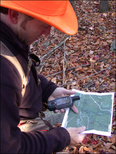
The satellite images make it easy to see logging roads and the edges of cuts – what we call “hard edges” in the book – and sometimes you can see what we call “soft edges,” like old cut edges and overgrown roads. You also see the topography, so you can tell where slopes and drainages are, swampy areas, streams, rivers and other important features. You can rotate the images to change from the sky view to looking almost from ground level. Cool stuff!
Google Earth continually evolves, but at this writing it also:
> Shows the cardinal directions (north, south, east, west), meaning you know where the sun rises and sets relative to the covers you want to hunt, which can help. We’re happy just to find a good cover whenever we can and hunt it however we’re able.
> Allows you to mark an area with a tag or heading.
> Gives you historical views (usually annual), meaning you can see how an area has changed over time, which can be helpful to gauge the age of cuts.
> Lets you put layers on the map – including roads, terrain and state/national park boundaries, though we’re not sure the boundaries are completely accurate.
When we first started using Google Earth to find covers, some of the satellite images were older and/or only showed certain seasons (e.g., winter only) and/or were blurry. But it seems like Google has been quickly updating the images and the resolution keeps improving, though it still isn’t as good as we’d like it!

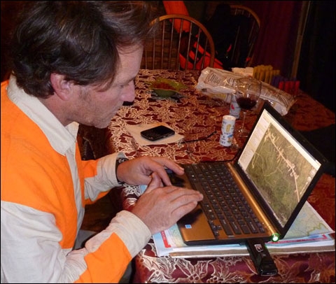
Take a Laptop
Using Google Earth is important not just for pre-hunt scouting, but also post-hunt. You might find that, when hunting, you stopped at a hardwood edge of a productive cover without realizing that a half-mile through those hardwoods was another cut. Or you might have found a new, good cover and thought you remembered seeing the same sort of habitat in another area some miles away.
This is a good reason to make sure you have a laptop and internet connection whenever you’re on an extended hunting trip. We make sure we do. When we hunted the first week of this year’s grouse season in Maine, we had a laptop with a Verizon cellular modem and by the second night of a 6-day hunt we were already using it.
Why? Even with all that pre-hunt satellite scouting and lots of hunting experience in that particular area, every year is different. Our pre-hunt Google Earth scouting was based on what we’d seen before and what we look for. Some of that applied this year, some didn’t. So as part of the effort to refine what we found, we hit Google Earth. It helped, but under the conditions we found – lots of leaves, ground vegetation and wind – it didn’t help as much as it could have.
Not a Bird-Finding Miracle But…
The more you use Google Earth – the more you hunt and use Google Earth’s capabilities before and after you hunt – the more you’ll learn, and the more you’ll be able to refine your bird-scouting and bird-finding both outside and inside the woods.
All that said, Google Earth isn’t a bird-finding miracle, and it isn’t going to do the most important work for you. The only way to find out if your satellite scouting is any good is to get in the woods and look. But at least you’re not going in blind, which is a big advantage.
And if you’re “Serious” about your bird hunting, like we are, having a plan going in definitely beats showing up somewhere with no intel at all. Plus it’s fun.
Jay C. Kumar and Brendan T. Haines are authors of the new book, Serious Grouse Hunting, Book 1, which one newspaper reviewer has called ” without a doubt, one of the best books on the subject of ruffed grouse ever published.” Order it at their website,www.SeriousBirdHunting.com, the only site on the web with news (and more) on all upland species. In real life they are entrepreneurs, Jay in media and Brendan in outdoor advertising.

Irwin Greenstein is Publisher of Shotgun Life. Please send your comments to letters@shotgunlife.com.
Comments